


A Simple Explanation of the GPS Coordinate System
Copyright © June 1, 2013 by Robert Wayne Atkins, P.E.
All Rights Reserved.
Let's begin by looking at a simple ordinary circle.
- Degrees = ° : A circle can be divided into 360 equal parts. Each part is called a degree. If you look at a protractor then you will see one-half of a circle and the number of degrees shown on the outside scale of the protractor will increase from 0 degrees to 180 degrees.
- Minutes = ' : One degree can be divided into 60 equal parts. Each part is called a minute. This is similar to the way we measure time. Each hour is divided into 60 minutes. However, on a circle one minute is 1/60th of the distance between two consecutive degree marks. This distance is very small and the human eye cannot see this distance on a small circle. But if you significantly increase the diameter of the circle to increase the circumference around the circle then you could see one minute on the outside of a very, very large circle.
- Seconds = " : One minute can be divided into 60 equal parts. Each part is called a second. This is also similar to the way we measure time. Each minute is divided into 60 seconds. However, on a circle one second is 1/60th of the distance between two consecutive minute marks. This distance is so small that you can't see it with the unaided eye unless you have an extremely large circle. The earth is large enough that it is easy to see second measurements on a large map of one small part of the earth.
There are three methods for showing degrees, minutes, and seconds as follows:
- Method One: Use all three measurements at the same time but remember that minutes and seconds cannot exceed sixty.
80° 51' 45" = This would be read as 80 degrees 51 minutes 45 seconds.
- Method Two: Use degrees and minutes and convert seconds into decimal minutes but remember that there are sixty seconds per minute.
80° 51.75' = This would be read as 80 degrees 51.75 minutes. This is the same measurement as above after converting the 45 seconds into minutes as follows: 45 / 60 = .75 minutes.
- Method Three: Use degrees and convert minutes and seconds into decimal degrees but remember that there are sixty minutes per degree.
80.8625° = This would be read as 80.8625 degrees. This is the same measurement as above after converting the 51.75 minutes into degrees as follows: 51.75 / 60 = .8625 degrees.
In summary, 80° 51' 45" = 80° 51.75' = 80.8625°. These are all the same exact measurement even though they are shown in different formats.
The GPS receiver I purchased about twelve years ago uses the second method above to identify coordinates. The Magellan GPS receiver I recently purchased uses the third method above to identify coordinates.
GPS Coordinates
The earth is not a perfectly round sphere. Instead the earth is a biaxial ellipsoid. The diameter of the earth at its equator is about 0.3% longer than the diameter of the earth between the north and south poles. Therefore, although the earth is not a perfect sphere, it is usually drawn as a sphere because it is very close to being a sphere.
GPS receivers use the following coordinate system. However, there are other coordinate systems available and the manufacturer of a specific map may select a different coordinate system for use on the maps they produce.
An international conference met in the year 1884 and they agreed upon the following universal system for locating positions on the face of the earth.
A specific point on the face of the earth can be defined by the intersection of three points as follows:
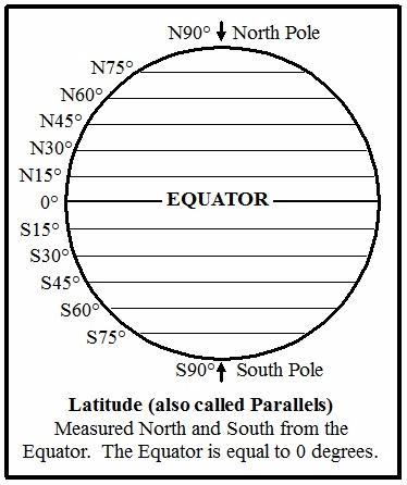
- Latitude or Parallels: The equator is used as the reference point for latitude. The equator is an imaginary line that goes around the center of the earth approximately halfway between the north pole and the south pole. The latitude of the equator is zero degrees. As you travel north from the equator towards the north pole the distance north is expressed as degrees north with the north pole being 90 degrees north of the equator. As you travel south from the equator towards the south pole the distance south is expressed as degrees south with the south pole being 90 degrees south of the equator. The imaginary lines going north and south from the equator are all parallel to the equator and to each other. (Note 1: If the north and south designators are not used then degrees north of the equator are shown as positive values and degrees south of the equator are shown as negative values.) (Note 2: More precisely, the equator is where the sun is directly overhead during the March and September equinoxes.)
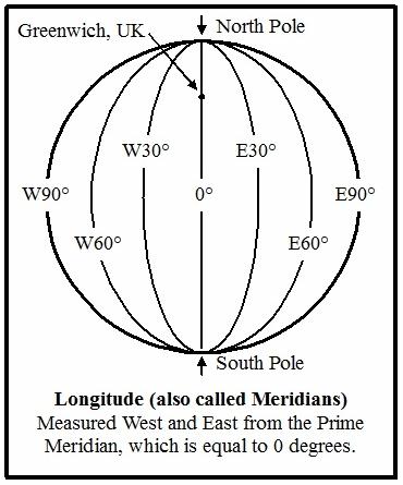
- Longitude or Meridians: The prime meridian is used as the reference point for longitude. The prime meridian is an imaginary line that goes across the earth from the north pole to the south pole and it passes through the British Royal Greenwich Observatory. This observatory is near London in the United Kingdom. The longitude of the prime meridian is zero degrees. As you travel west from the prime meridian the distance west is measured as degrees west until you get exactly halfway around the earth to 180 degrees west. As you travel east from the prime meridian the distance east is measured as degrees east until you get exactly halfway around the earth to 180 degrees east. The line where 180 degrees west and 180 degrees east meet is called the International Date Line and it is in the Pacific Ocean. On the illustration of longitude on the right, only one-half of the earth is shown with the prime meridian in the center. Therefore the degrees west and east stop at 90 degrees on the illustration. But the degrees west and east continue around the other side of the earth until they meet at 180 degrees on the opposite side of the earth straight across from the prime meridian. (Note 3: If the west and east designators are not used then degrees east of the prime meridian are shown as positive values and degrees west of the prime meridian are shown as negative values.)
- Elevation or Altitude: Altitude is a measure of the distance above sea level where sea level is set at zero altitude. Altitude may be measured in either feet or meters (or miles or kilometers) depending on the nation in which you live.
Now for a practical example. The intersection of Interstate 75 and Interstate 85 in the northern part of the city of Atlanta, Georgia in the United States of America could be stated as follows:
N33.79031° and W84.39083° at an elevation of 1,105 feet above sea level.
The compass directions N, E, S, and W may be shown in front of the number of at the end of the number.
For example, N33.79031° = 33.79031°N and either method may be used when reporting GPS coordinates.
Respectfully,
Grandpappy.
Grandpappy's e-mail address is: RobertWayneAtkins@hotmail.com